
Nain Singh
By the early 1860s, the British and Russian Empires simultaneously attempted to spread their influence into Tibet, a region which was at the time still tenuously under the control of the fading Qing Empire in China. Tibetan leadership, in an attempt to forestall culture erosion and retain its connections with the Chinese, closed its borders to Europeans of all sorts on penalty of death. Captain Thomas G. Montgomerie of the Royal Engineers, tasked with the exploration and mapping of Tibet, developed a plan to use trained natives to surreptitiously take the measurements for which British agents, regardless of their talent or preparation, would be much more vulnerable to discovery. After being asked for recommendations of loyal and talented locals who could be taught techniques in infiltration and surveying, British Education Officer Edmund Smyth suggested to Montgomerie a 33-year-old local schoolteacher named Nain Singh.
Rai Bahadur Nain Singh Rawat, known primarily as Nain Singh, hailed from Milam, a high mountain village situated on a popular trade route in the Johar Valley. During Nain’s younger years, he had developed a great familiarity with Tibetan language, manners, customs, and culture while assisting his father, a travelling merchant, on long journeys. Short and powerfully built, Nain had accompanied several German expeditions in earlier years before serving for five years as the Headmaster of the English-language Milam Government Vernacular School in his home village.
On Smyth’s recommendation, Nain, along with his brother Kalian and cousin Mani, reported to the British Survey in India’s headquarters in Dehradun, in what is now the state of Uttarakhand in northern India, on January 12, 1863. For the next two years, Captain Montgomerie personally trained the men, along with several others, in numerous scholarly and tactical disciplines, including astronomy, surveying, cartography, various cultural studies, and disguise, and developed detailed cover stories that would explain their presence to questioning Tibetan authorities. Montgomerie referred to the native surveyors as a group by adopting the Hindi term Pundit, meaning an amateur but learned scholar; in order to preserve their anonymity, he also referred to each of the surveyors by a number or a code name. Nain Singh, by these standards and as acknowledgment of his respected station, was soon known as ‘Pundit Number One’.
The Pundits planned to primarily disguise themselves as Buddhist pilgrims traveling to Tibetan holy sites, and for the sake of preserving that image, the Royal Engineers set about modifying the traditional accouterments of such a holy man. Carpenters built false bottoms into the Pundits’ traveling chests in order to hide a sextant, and hid portions of mercury within cowrie shells; from there, it could be poured into the Pundits’ tea bowls when needed to construct an artificial horizon. Tailors sewed concealed pockets into their clothing, and Engineers concealed thermometers in the Pundits’ walking sticks, so that the Pundits could easily determine altitude by measuring the temperature of boiling water. Tibetan prayer beads ordinarily consisted of exactly 108 beads, but the Pundits’ had the round number of exactly 100 beads; with their walking pace having been carefully measured, a Pundit could easily measure 10,000 paces by flipping one bead every 100 paces. Nain’s pace measured exactly 33 inches long, so one complete circuit of the beads measured almost exactly five miles.
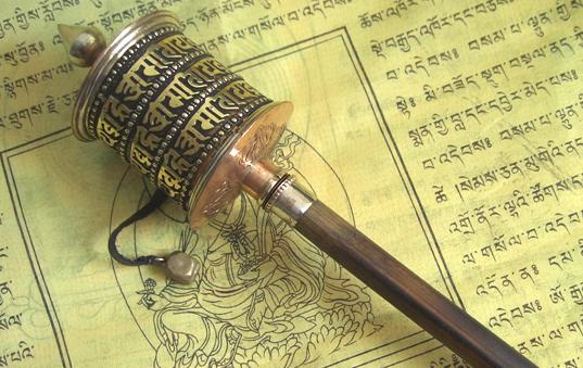
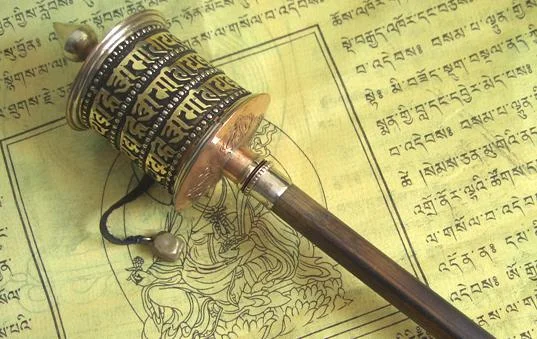
A Tibetan Prayer Wheel
Finally, every pilgrim also carried a Tibetan Prayer Wheel, consisting of a rotating wooden chamber revolving around a hollow copper cylinder. By holy tradition, the copper core contained the Buddhist mantra “Om! Mane Padme Hum” (which translates to “Hail! Jewel in the Lotus”); theologically, the spinning of the wheel then elevated these prayers up to heaven as the pilgrim traveled. British Royal Engineers secreted a compass in the lid of the wheel, and replaced the chant with blank paper that would serve as the Pundits’ log book, onto which they would record their measurements and observations. By the tenets of the Buddhist faith, these alterations would be seen not only as evidence of a deceptive invasion of their sacred lands, but as outright heresy as well, and Tibetan punishments, whether physical or spiritual, were particularly brutal.
In January 1865, the Pundits, having completed their training, calibrated their instruments in the lowland town of Bareilly, in the region of Uttar Pradesh, where the elevation and location were already known values. Their initial plan was for Nain and his cousin Mani to travel from the Indian border town of Kumaon, north across the Himalayas to the area surrounding Lake Manasarover in Tibet and then east to Lhasa, but that route proved to be impassable due to winter weather. Instead, they traveled east to the Nepalese capital of Kathmandu, and headed north from there.

The view from Nepal, across the Himalayas into Tibet
The two Pundits left Kathmandu on March 7, 1865 and navigated the courses of several interlocking rivers until they crossed the towering Himalayas, crossing into Tibet at the border post of Kirong. Unfortunately, after having paid a poll tax for entry into Tibet, the commander of a second guardpost refused to believe their story that they were horse merchants, so they were forced to return to Kathmandu. As chance would have it, Nain and Mani discovered two groups of merchants heading into Tibet; in order to increase their chances of success, they split so that each would accompany one caravan. Although Mani’s caravan failed to provide access, Nain was successful, and with them he crossed the Himalayas and soon found himself on the Tibetan Plateau.
The Tibetan Plateau is large, flat, and mostly arid expanse between the lush but low Tarim River Basin to the north and the tallest mountain range in the world to the south. Flowing from west to east across the plateau, and roughly parallel to the ridge of the Himalayas, the Tsangpo River was (and still is) the highest major waterway in the world, spending most of its existence at roughly 14,000 feet above sea level, the consistent equivalent of the summit of Pikes Peak in Colorado. After the party crossed the river near the site of one of the many Tibetan monasteries that dotted the bank, they found themselves at the junction of the Jong-lam trade route. To the west, the road headed toward Kashmir and the headwaters of the Shangpo, and to the east it traveled downriver toward Lhasa. Since the merchants had business to the west, Nain split with their party and headed east toward Lhasa, even though it would entail the risk of traveling alone.
Fortunately, Nain soon met up with a caravan of merchants from the Kashmiri region of Ladakh who were also heading east toward Lhasa, and he learned from them that the Tsangpo flows east past Lhasa, then turns south into India; this was vital information to Nain, as charting the course and destination of the river was one of the Survey of India’s highest priorities. Ultimately, he had to abandon the Ladakhi caravan when the captain decided to complete their journey via a riverboat; Nain, in his records, neglected to record the excuse he provided for preferring to walk such a long distance, so that detail of his tale remains a mystery.

The Shangpo River
Nain continued down the Tsangpo River, crossing once again to the southern bank before reaching the town of Shigatse. When he was invited to the Tashilhunpo Monastery to meet the Panchen Lama—second within the Tibetan Buddhist faith to only the Dalai Lama —Nain was concerned for his security because Buddhists of the time believed that the Panchen Lama could see the heart of all before him. Fortunately, Nain soon discovered that the 11-year-old Panchen Lama was no more omniscient than any other boy his age.
In January 1866, a full year after departing, Pundit Number One reached the city of Lhasa, having measured every step during his journey. He discovered the city to be a thriving trading center consisting of many merchants and peddlers, but also somewhat run-down and messy. While in Lhasa, Nain used what little money he had to rent himself two small rooms in a local caravanserai; from there, he secretly recorded 20 different stellar and solar observations in order to determine the city’s exact location and altitude, and also detailed numerous observations concerning the city’s culture, people, logistics, and general atmosphere. At one point, he also made a short journey as far as he dared to the east, recording his farthest measurements where the Tsangpo meets with the Kyi Chu tributary. On another occasion, he traveled to the Sera Monastery north of town, where he met the 12th Dalai Lama, who, like the Panchen Lama, was still a child; after a ceremonial drink of yak butter tea, the young God-King asked the Pundit about his health, and ushered him on his way. Short on money, Nain earned income by teaching accounting to Nepalese traders; two other traveling merchants noted the unusual vocation for a religious pilgrim and correctly deduced Nain’s actual intention; rather than turn him in, however, they gifted him with some extra money to help with his undertaking, to Nain’s great relief.
Nain remained in Lhasa for three months. Over time, he got more and more nervous at being discovered, especially since his notes far outmassed the storage capacity of his tiny prayer wheel; any discovery of the loose sheets would prove disastrous on several levels. After witnessing the public beheading of a Chinese visitor accused of causing trouble, Nain decided to return west as soon as possible. As fate would have it, the Ladakhi caravan that he had befriended earlier was preparing to leave once again for their homelands; Nain, claiming fear of bandits, gained permission from the caravan captain to travel along with them in their return trip.
The caravan’s route took them down the full extent of the Jong-lam, continuing west past the monastery where Nain had joined the path on the way in. Nain happily agreed for the duration of the 500 mile trek, still counting every step and secretly recording all manners of measurements, until he traced the Tsangpo back to its source in Lake Manasarowar, in Tibet’s southwestern corner. From there, Nain split from the caravan and headed southwest toward British India; however, without the protection of the caravan guards, he was soon captured by brigands and held captive. Escaping from their confinement, Nain finally crossed back over the Himalayas and, on October 27, 1866, he returned to Dehradun and handed his amassed information over to Captain Montgomerie. After more than 1,200 miles, having counted every one of 2.5 million steps, Nain Singh had provided enough information for Montgomerie’s cartographers to correctly plot the Tsangpo River’s course across the full width of Tibet, and to place the city of Lhasa within two seconds (00.02 degrees) on the latitudinal scale.

A 2004 stamp honoring Nain Singh and the Survey of India
Throughout the years that follow, Captain (later Lt. Col.) Montgomerie published numerous maps based on the Pundits’ measurements in the Royal Geographic Society’s Journal. Even though the methodology clearly detailed practically every aspect of the Pundits’ clandestine intrusions into Tibetan territory, knowledge of their excursions failed to endanger any future missions; Russians kept quiet because they benefitted from the maps, and the Chinese agents in London were unaware of the Journal’s existence. The Survey of India continued until 1894, but only ever employing 20 Pundits over the entire duration. Mani and Kalian, cousin and brother to Nain, established themselves as distinguished Pundits in their own right.
Nain Singh made four more journeys into Tibet, with his last taking place in 1874 and covering more than 1,300 miles. Suffering from failing health and eyesight, Nain retired from active expeditions, but continued to teach surveying methods to new recruits. The Crown awarded Singh the RGS Victoria/Patron’s Medal in 1877 and invested him as a Companion of the Indian Empire (CIE) in that same year. The Paris Geographical Society also recognized his achievements with a gift of a gold chronograph, and India awarded him a land-grant of two small villages and a monetary award. He continued a relatively humble life until dying of a heart attack in 1895 while visiting one of his villages.

Links and Sources:
Trespassers on the Roof of the World: The Secret Exploration of Tibet, Kodansha International, 1995.
The Great Game, by Peter Hopkirk, Oxford University Press, 1991.
“Nain Singh: An Intrepid Explorer”, by Wg Cdr Joseph Thomas, 2013, retrieved via Guftagu here.
“Nain Singh’s Last Exploration”, from Frontline on PBS.org, 2014, available here.
“Walking with Nain Singh”, by Shyam G. Menon, in Hindu Magazine, Feb. 2 2013, available online here.
Photo “View to Tibet from Taruche View Point, Rasuwa, Nepal” by Reise Koenig via Google Earth.
Photo of the Tsangpo River from the website “The Land of Snows”, available here.
“The Secret Surveyor of Tibet” © 2016 by James Husband